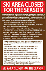
ADVISORY
Ski area work may be performed at any time, including but not limited to heavy equipment use, vehicle operation, chairlift maintenance operations, ski run maintenance and facility maintenance. It is your responsibility to stay away from, and not interfere with, any equipment, machinery, or work zones. DO NOT ENTER any restricted areas or work zones.
• FACILITIES ARE NOT MAINTAINED FOR PUBLIC USE.
• MOUNTAIN ENVIRONMENT HAZARDS EXIST AT ALL TIMES THAT
MAY CAUSE SERIOUS INJURY OR DEATH.
• The ski area exists on National Forest land and should you choose to enter this area, you are entering UNCONTROLLED, UNPATROLLED NATIONAL FOREST AREA ZONE and IT IS AT YOUR OWN RISK.
• TREAT THIS AREA LIKE BACKCOUNTRY AT ALL TIMES, INCLUDING USING SAFE TRAVEL AND ASSESSMENT SKILLS AND HAVING APPROPRIATE RESCUE EQUIPMENT AND PARTNER.
1. AVALANCHES may occur at any time, EXTREME CLIFF AREAS and other mountain hazards exist at all times and hazards are not marked.
2. The ski area is NOT CONTROLLED FOR AVALANCHES.
3. NO SKI AREA MEDICAL RESPONSE PERSONNEL OR SKI PATROL SERVICES ARE AVAILABLE.
4. Access to any areas is STRICTLY AT YOUR OWN RISK.
5. No bicycle or motorized vehicle access at any time.
6. 911 and/or Search and Rescue response is typically a minimum of hours away at best. Emergency response may not be possible.
7. These policies and warnings apply to all areas within the ski area boundary. Other signage is not in place.